


Belvédère du Galibier depuis le Lautaret

cron
User
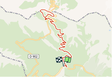

Length
12.9 km

Max alt
2666 m

Uphill gradient
699 m
Km-Effort
22 km

Min alt
1963 m

Downhill gradient
698 m
Boucle
Yes
Creation date :
2024-07-05 14:03:32.48
Updated on :
2024-07-05 14:04:38.075
5h03
Difficulty : Difficult

FREE GPS app for hiking
 SityTrail
IGN / Geographical institutes
SityTrail Plus
The world is yours!
About
Trail Walking of 12.9 km to be discovered at Provence-Alpes-Côte d'Azur, Hautes-Alpes, Le Monêtier-les-Bains. This trail is proposed by cron.
Positioning
Country:
France
Region :
Provence-Alpes-Côte d'Azur
Department/Province :
Hautes-Alpes
Municipality :
Le Monêtier-les-Bains
Location:
Unknown
Start:(Dec)
Start:(UTM)
296483 ; 4990915 (32T) N.
Comments